On Sunday morning, November 23, the ground beneath Ethiopia’s Afar region shattered twelve millennia of dormancy. Hayli Gubbi volcano, a mountain with no recorded eruptions since the Ice Age, exploded without seismic warning. Ahmed Abdela, an eyewitness, described the moment to news agencies: “It felt like a sudden bomb had been thrown, accompanied by smoke and ash.” The eruption exposed a critical blind spot in volcanic science—a region so understudied that earth scientists had only partial understanding of what lay beneath the surface.
A Giant Awakens After Millennia
Hayli Gubbi occupies an extraordinary place in geological history. The volcano has no known eruptions during the entire Holocene, the 12,000-year span from the last Ice Age to today. This silence outlasted all of recorded human civilization. Writing, cities, agriculture, and empires—every human milestone occurred while this mountain lay dormant. Volcanologist Simon Carn from Michigan Technological University confirmed the rarity: the volcano “has no record of Holocene eruptions.”
For scientists studying volcanic systems, this eruption shattered fundamental assumptions about what dormancy truly means. Arianna Soldati, a volcanologist from North Carolina State University, articulated the unsettling truth: “So long as there are still conditions for magma to form, a volcano can still erupt even if dormant for 1,000 or 10,000 years.” Dormancy does not mean extinction—it means temporary quiet. The Afar region sits at the East African Rift Zone, where tectonic plates actively pull apart, continuously generating magma beneath the surface.
An Explosive Eruption Defies Expectations
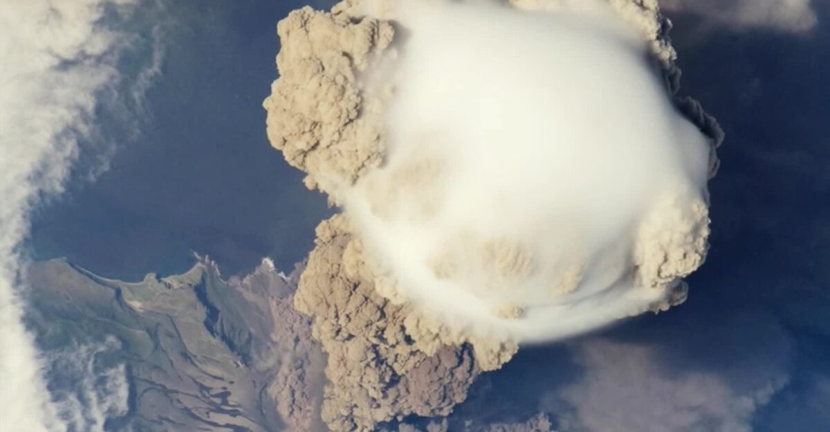
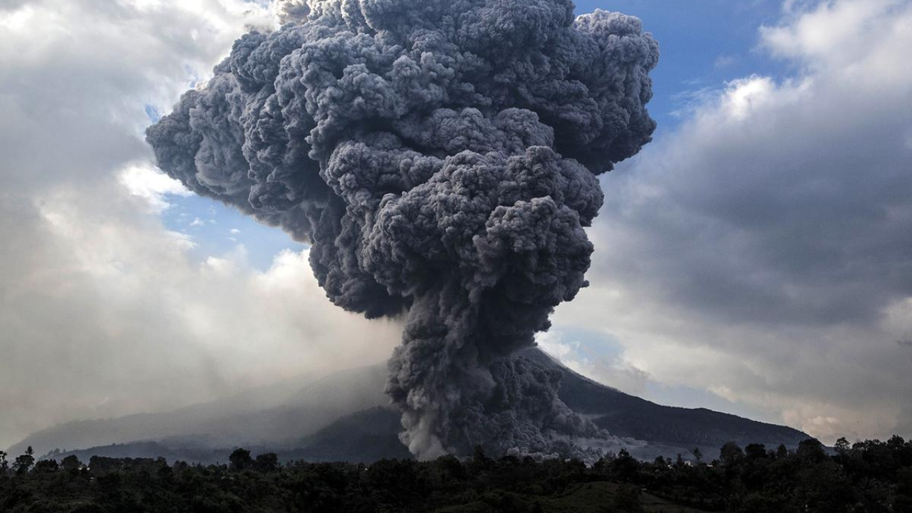
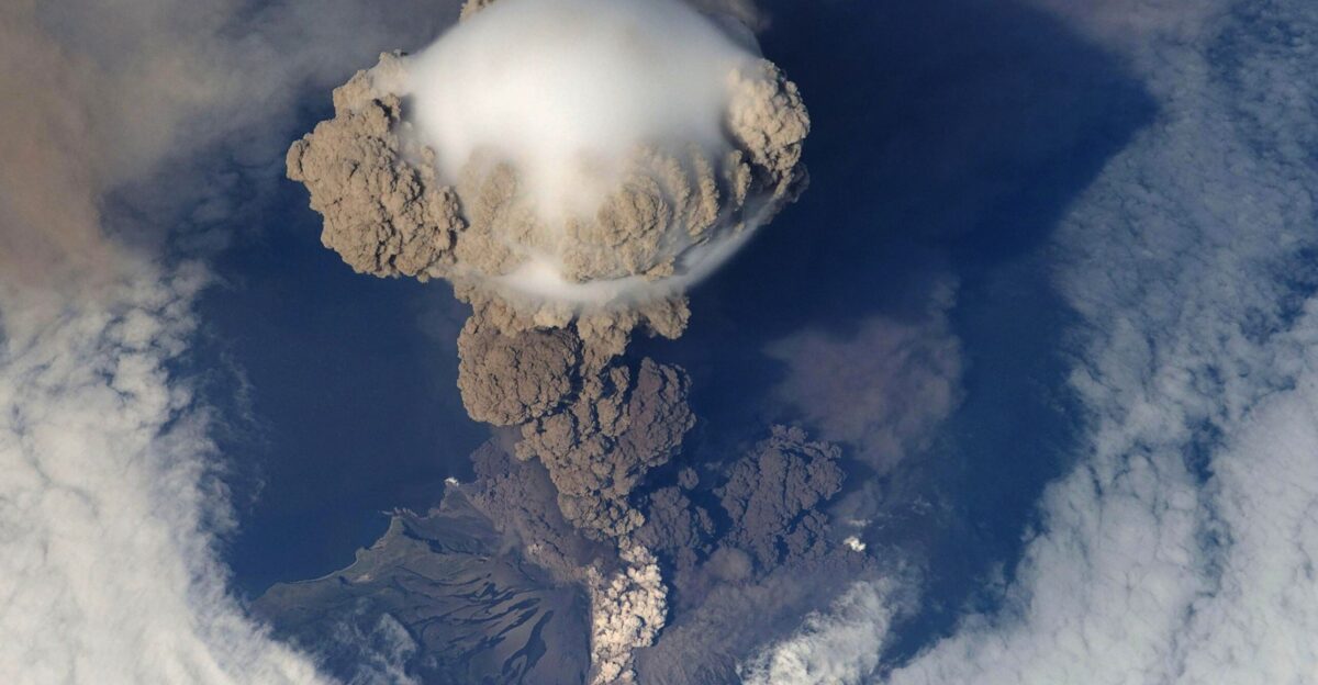
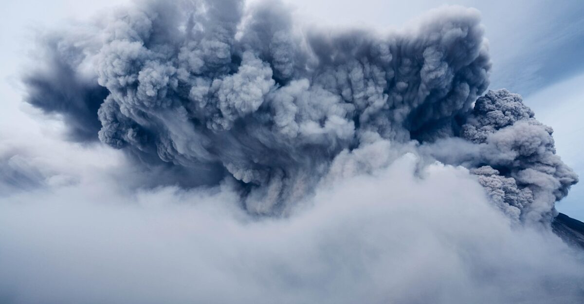
Around 8:30 a.m. UTC that Sunday, ash and gases exploded upward with ferocity rare for shield volcanoes. The plume rocketed to approximately 9 miles high, piercing the atmosphere above Everest’s peak. Within hours, satellites captured roughly 220,000 tons of sulfur dioxide spreading into the upper troposphere in a toxic umbrella cloud visible from space.
Volcanologists were stunned by the eruption’s violence. Hayli Gubbi is a shield volcano, the same type as Hawaii’s Mauna Loa, which typically oozes lava gently rather than launching ash columns explosively into the sky. Juliet Biggs from the University of Bristol expressed the rarity: “To see a big eruption column, like a big umbrella cloud, is really rare in this area.” The explosive ash-filled eruption contradicted what conventional models predicted about shield volcanoes in the Rift Valley.
Researchers later recognized subtle warnings visible only to satellite observers. In July 2025, nearby Erta Ale erupted, and satellite data revealed an underground magma intrusion spreading southeast toward Hayli Gubbi, extending over 20 miles underground. The volcano’s surface began rising by centimeters. White clouds appeared at the summit in late July. Yet these whispered signals—detectable only to attentive earth scientists—did not trigger evacuation protocols.
Ash Crosses Continents in 48 Hours
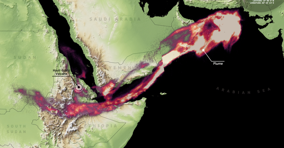
What happened next defied geography. The ash hitchhiked on the subtropical jet stream, traveling 2,000 miles eastward in relentless drift. By Monday evening, volcanic plumes crossed the Red Sea, drifting over Yemen and Oman. By Tuesday morning, ash reached northern India and Pakistan, spreading across Gujarat, Rajasthan, Delhi, Haryana, and Punjab before continuing toward China.
European Union Copernicus satellites measured the sulfur dioxide plume extending approximately 3,700 kilometers from Ethiopia toward the Arabian Sea by November 24. One volcano in remote Ethiopia had disrupted the skies above two continents within 48 hours.
The ash cloud’s arrival created immediate chaos for air travel. Air India, India’s national carrier, canceled 13 flights to conduct mandatory safety inspections on aircraft that had flown through ash-contaminated airspace. Seven international flights were cancelled, and 12 were delayed at Delhi airport in a single day, affecting routes to Hong Kong, Dubai, Jeddah, Helsinki, Kabul, and Frankfurt. Aviation authorities issued urgent directives: avoid ash regions, monitor engine performance, and prepare for disruptions.
Communities Face Ash-Covered Pastures
No lives were lost in the blast itself, but the aftermath dealt a different blow. Nearby villages, including the tourist hub of Afdera, were blanketed in thick volcanic ash that still covered the landscape days after the eruption. For pastoralist communities that depended entirely on livestock herding, the consequences were catastrophic. Local administrator Mohammed Seid expressed grave concern that animals faced barren, ash-covered grazing lands with virtually nothing to eat. A geological event became an economic emergency.
A Humbling Reminder of Earth’s Power
The eruption of Hayli Gubbi delivered a humbling reminder: the ground beneath our feet is far from inert. A volcano considered extinct by historical standards unexpectedly demonstrated that dormancy and danger are not opposites. The ash that traveled thousands of miles disrupted aviation, threatened livestock livelihoods, and forced nations to reassess volcanic hazard monitoring across entire regions.
Juliet Biggs articulated the sobering reality: “It really just shows how understudied this region is.” The volcano’s remote location, combined with limited historical records and sparse seismic monitoring infrastructure, meant that earth scientists had only a partial understanding before it erupted. Derek Keir, a geologist from the University of Southampton who was in Ethiopia during the eruption, collected ash samples to determine magma composition. Laboratory analysis will help confirm whether dormancy truly spanned the entire Holocene or whether the historical record contains gaps.
For pastoralists, airlines, and earth scientists scrambling to understand what they missed, Hayli Gubbi proved the planet operates on its own timescale. Twelve thousand years of silence offer no guarantee of future quiet.
Sources:
Smithsonian Institution Global Volcanism Program – Hayli Gubbi Volcano Database (November 2025)
NASA Earth Observatory – Satellite Imagery and Ash Plume Documentation (November 23-26, 2025)
European Union Copernicus Sentinel-5P – Sulfur Dioxide Plume Measurements (November 24, 2025)
Toulouse Volcanic Ash Advisory Centre (VAAC) – Official Eruption Reports and Aviation Alerts (November 23-24, 2025)
Associated Press – Ethiopia Volcano Coverage and Flight Disruption Reports (November 24-25, 2025)
VolcanoDiscovery – Field Reports and Real-Time Eruption Monitoring (November 25-26, 2025)