
On December 10, 2025, Governor Bob Ferguson hit the emergency button for the whole state as a monster atmospheric river dumped record rain. Rivers everywhere swelled at once, pushing levees to the breaking point in a nail-biting 24-48 hours.
What turns a stormy week into a full-blown crisis? It’s the perfect storm of heavy rain, melting snow, and bad timing hitting populated areas hard. Families pack bags, roads close, and heroes scramble.
Rivers Rage, Help Rushes In
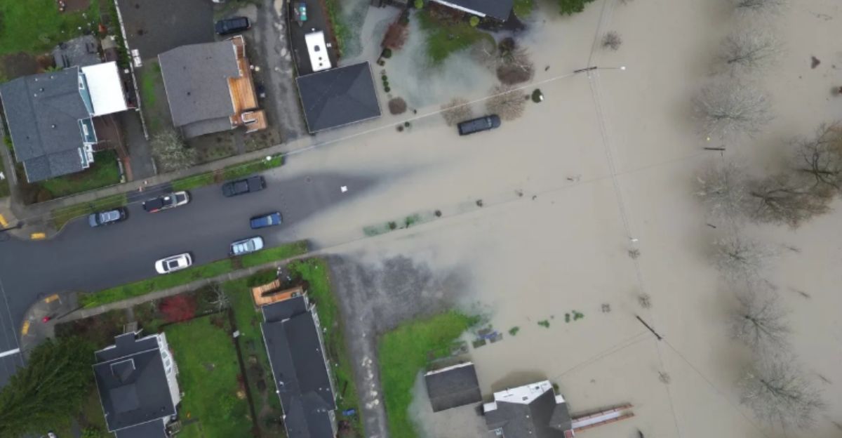
From the Canadian border to southwest Washington, rivers hit major flood levels all at once, swallowing roads, bridges, and thousands of homes. Over 300 National Guard troops jumped into action, stacking sandbags and rescuing folks as shelters popped up everywhere.
Heroes in rain gear battle the deluge, but isolated towns cry for faster help. This isn’t just water, it’s a statewide scramble that tests everyone’s grit. How high will it go?
The Sky’s Water Superhighway

Atmospheric rivers are like sky rivers, narrow bands of super-moist air that slam the West Coast with floods. This beast kicked off December 8, 2025, and it’s one of the strongest ever for Puget Sound, promising up to 10 inches of rain in the mountains.
Warm temps melted snowpack fast, turning mountains into runoff machines. Remember 2021’s floods? This feels eerily similar, with snow levels soaring and rivers exploding. Families watch helplessly as forecasts worsen.
Rain Records Get Smashed

By December 9, spots in western Washington saw over 7 inches of rain in just 48 hours. Olympia got 3.03 inches on December 8 alone, a new high. Mountains brace for 4-8 more inches by December 11, pushing every creek and river toward flood stage across Washington and Oregon.
Stuck weather patterns mean the downpour won’t quit soon. Streets flood, branches snap, and gauges overflow like bursting balloons. It’s not just wet; it’s a relentless assault turning daily life upside down. “This is not just a one- or two-day crisis,” Gov. Bob Ferguson said at a news briefing. “These water levels have been historic, and they’re going to remain very high for an extended period of time.”
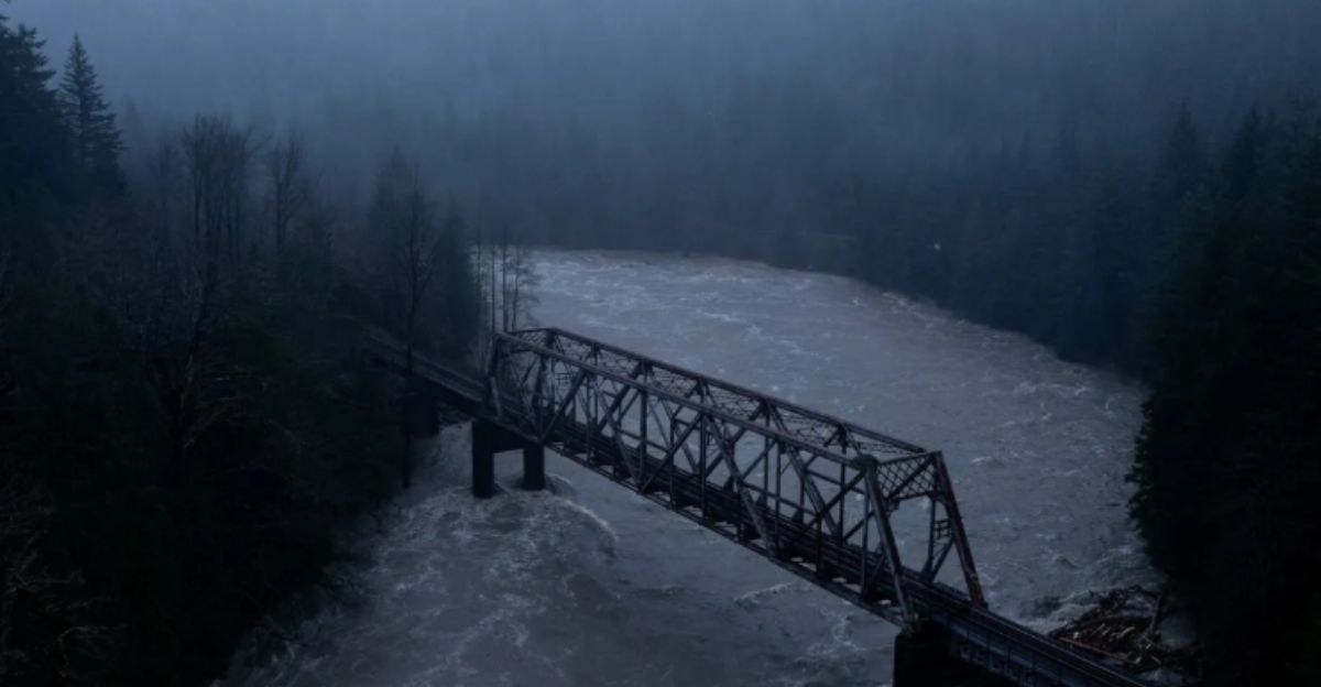
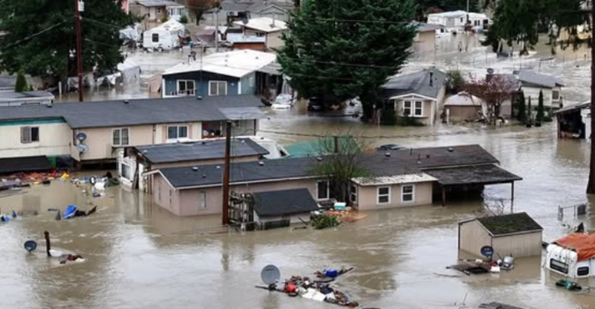
Skagit River Breaks All Limits
The Skagit River hit a jaw-dropping 37feet near Mount Vernon on December 11, smashing its 1990 record. That’s over 100 years of data gone in a splash! The Snohomish River joined the party, topping its all-time high too. Officials saw it coming and sounded alarms early.
According to AP News, “The river crested overnight at 37 feet (11 meters) in the valley’s biggest city, Mount Vernon, surpassing the previous record by a few inches.”
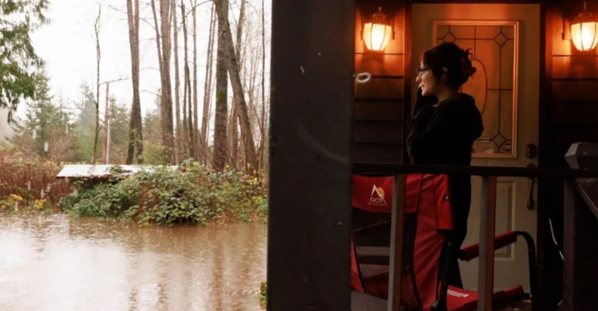
Mass Exodus Underway
Skagit County issued “go now” orders for over 75,000 people, wiping out Burlington and parts of Mount Vernon. Orting got hit too, with statewide alerts reaching 100,000. Roads turned into rivers, cutting off towns as the National Guard launched rescues.
Thousands grabbed pets and fled, but gridlock and impassable routes trapped some. Families wade through waist-deep water, headlights piercing the gloom. It’s chaos, but neighbors help neighbors load trucks.
Heartbreak in the Waters

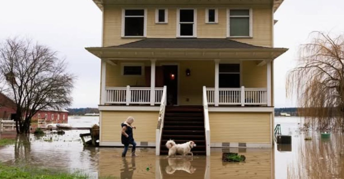
Lewis County’s Randle and Packwood got hammered by the Cowlitz River’s double crest, rescuing folks from drowned cars. Stehekin lost water and power to mudslides; Leavenworth’s streets flooded, services cut. Wild elk swam for their lives, homes floated away, it was pure heartbreak.
Families clutch pets and soggy photos, facing days or weeks displaced. Rescuers in boats pull people from rooftops while surrounded by chaos.
Roads and Rails Go Dark

I-90 got buried by North Bend mudslides, 50 miles of US 2 at Stevens Pass gone, US 12 slicing towns off the map. I-5 ramps closed in Napavine; Amtrak halted Seattle-Vancouver trains. Levees groaned, floodwalls at breaking point, borders stopped trucks.
Supply chains snapped as groceries were scarce and towns were isolated. Crews with bulldozers battle debris mountains, but nature fights back. Imagine no way out, lights flickering off. It’s a logistical nightmare testing emergency pros.
Floods Hit Farms and Neighbors

Western Washington’s river frenzy endangers 50,000+ homes, mirroring billion-dollar disasters past. FEMA Region 10 gears up federal aid. Next door, BC’s Fraser Valley evacuated 370+ spots in Abbotsford; Highways 1, 7, 99 shut.
Skagit Valley farms drown as barns are underwater and crops are ruined under gloomy skies. The economic ripples spread far and wide as food prices spike and jobs vanish. But aid crosses lines, uniting regions.
Climate’s Role in the Chaos
These sky rivers bring 30-50% of our yearly rain, but climate change cranks up their power and frequency. Post-2021 and 2024 floods, this one melts snow above 7,000 feet with warm plumes. Stalled highs near California trap the moisture which prolongs the pain.
Charts show trends climbing with more extremes ahead. It’s not just weather; it’s our warming world rewriting rain rules.
Levees on the Brink

Levees face doomsday tests as crests top their design limits and Skagit crews fear overtopping. The threat is real as 5,000 tons of water per second, rips banks with log battering rams.
2021 saw failures cascade and more rain could trigger dominoes. Sandbag armies fight back, but erosion hides deadly tricks. “It’s going to take a while for the flood waters to recede,” said Robert Ezelle, director of the Washington Military Department’s emergency management division. “There’s a lot of water that fell in the mountains and it’s gonna take its time to work through the river drainages.”
Guard’s All-Out Push
Over 300 Washington National Guard troops hit the ground running by December 13, 2025, fanning out statewide with Humvees, helicopters, and truckloads of sandbags, but cracks show in the chaos. Remote hamlets like Randle in Lewis County waited hours for choppers as mudslides blocked roads, sparking frustrated calls.
It’s a high-stakes relay race against cresting rivers, bridging urban firepower with rural cries. Tensions simmer as cleanup lags behind the flood peak.
Leaders Step Up

Governor Bob Ferguson flipped the switch on December 10, 2025, proclaiming a statewide emergency, unlocking millions in rapid-response funds and mirroring Jay Inslee’s 2021 playbook that saved thousands. President Trump fast-tracked federal disaster declaration within 24 hours, unleashing FEMA Region 10’s machinery which included mobile kitchens, temporary bridges, and millions in initial aid commitments.
“I just signed a statewide emergency declaration in response to the intense flooding Washington State and Washingtonians are experiencing this week,” said Gov. Ferguson. “This, of course, allows us to seek federal funds to cover the cost of this response, which we anticipate will be significant. It also gives us the flexibility we need to respond quickly to keep Washingtonians safe in a fast-moving situation.”
Rebuilding Kicks Off
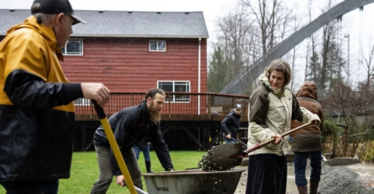
By December 14, 2025, the tide turns from chaos to comeback as 20+ shelters in Mount Vernon, Burlington, and Leavenworth buzz with 5,000 evacuees lining up for hot meals, blankets, and diapers. Volunteers hand out MREs and teddy bears, while National Guard bulldozers clear I-90 mudslides, reopening lanes by dawn.
Burlington stacks 50,000 sandbags for round two as temporary FEMA trailers roll in for 1,000 displaced families. Boil-water alerts hit Stehekin and Lewis County after mud choked intakes, echoing Montana’s 2022 playbook. Skagit Valley farmers salvage equipment from muck, eyeing massive million crop losses.
Doubts and What’s Next

No stabilization is in sight as new atmospheric rivers barrel in by late December, per Center for Western Weather and Water Extremes models. Skagit Valley farms face millions in crop hits, markets wobble, and past recoveries dragged 6-12 months with $1.8 billion tabs, per NOAA’s Billion-Dollar ledger.
Can Washington adapt with $2 billion resilient infrastructure, buyouts for flood traps, and snowpack buffers or repeat the cycle? Stakes skyrocket for families, farms, and futures.
Sources:
- WA Governor’s Office Emergency Proclamation
- USGS Skagit River at Mount Vernon Gauge
- NWS Seattle Flood Warnings & Rainfall Reports
- WA National Guard Press Releases
- FEMA Region 10 Situation Reports