
Rain poured over western Oregon and southwestern Washington beginning Thursday morning, December 18, creating a cascading crisis for a region still reeling from the previous atmospheric river that had struck just days earlier. With flood watches and warnings encompassing much of the Pacific Northwest’s populated areas—affecting roughly hundreds of thousands of residents across western Oregon and southwestern Washington—emergency officials activated disaster protocols to manage escalating threats from the second atmospheric river event.
The first atmospheric river had cut power to 137,000 Portland General Electric customers at peak outages on Wednesday, December 17, straining infrastructure already near capacity. Now, a second storm system brought renewed urgency as meteorologists warned of substantial rainfall and river flooding.
Coming Danger from Rain and Wind
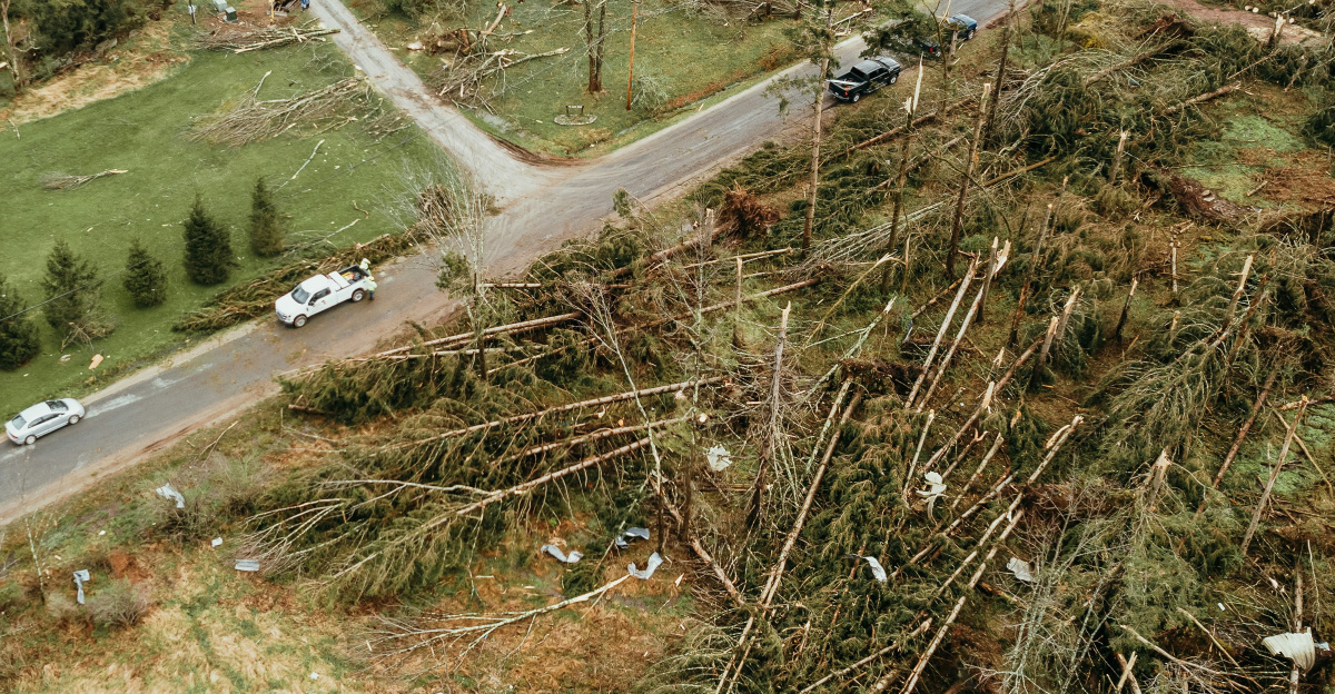
Meteorologists forecast 3 to 4 inches of rain over the next 48 hours beginning Thursday morning, with the heaviest precipitation expected Thursday afternoon and evening. Saturated soils from the preceding storm heightened risks of flooding and landslides along rivers and slopes throughout the region. Wind advisories issued for western Oregon, including the greater Portland-Vancouver metro area, warned of sustained winds up to 20 mph with gusts reaching 45 mph—threatening additional damage to trees and power lines already stressed by the earlier system.
Power Restoration Amid New Threats
Portland General Electric deployed restoration crews to capitalize on the brief Wednesday evening reprieve. The utility restored power to 97,000 customers by Wednesday evening, mobilizing more than 225 crews working overnight and through the day to repair downed lines. However, grid vulnerability persisted heading into the second atmospheric river, with officials acknowledging that additional outages were likely from the incoming system’s strong winds.
Flood Risks and Evacuation Concerns
The second atmospheric river triggered multiple major flood warnings for Oregon and Washington rivers, including the Clackamas River near Estacada, the Hood River near Tucker Bridge, and portions of the Cowlitz River in southwestern Washington. Low-lying areas adjacent to these waterways braced for surges, with potential evacuations looming for riverside communities.
Projections were severe: The Clackamas River near Estacada was expected to crest at approximately 25 feet late Thursday night into early Friday morning—reaching major flood stage and matching forecasts updated throughout Thursday. Johnson Creek in Southeast Portland was projected to reach 14.8 feet at 10 p.m. Thursday, threatening widespread inundation in the communities downstream. These projected river crests represented conditions that would flood buildings, inundate rural roads, and potentially isolate neighborhoods.
In Washington, communities along the Cowlitz, Green, and White Rivers faced renewed flooding risks as the second atmospheric river threatened to prolong and intensify water levels already elevated from the prior week’s record-setting floods. The National Weather Service warned that major flooding was expected to persist through at least Friday in multiple river systems.
Economic and Sector Disruptions

The cumulative impact of back-to-back atmospheric rivers created cascading economic consequences. Ports along the Columbia and Willamette rivers, along with feeder roads and rail connections near floodplains, risked operational delays that would ripple through regional supply chains. The timber and agriculture sectors, which depend on reliable transportation and stable water conditions, faced significant interruptions from heavy rain and flooding that extended into their critical harvest and storage periods.
Homeowners across flood-prone areas, particularly in Clackamas County and King County, Washington, anticipated rising insurance claims for water damage to basements, vehicles, and personal property. Standard homeowner policies often exclude flood damage, leaving many residents exposed to significant losses. Retailers anticipated demand spikes for pumps, dehumidifiers, sandbags, and temporary flood barriers as residents scrambled to protect property. Small businesses located near flood zones risked revenue loss from operational interruption, while municipalities faced escalating costs for emergency response, road management, cleanup, and worker overtime.
Health, Resilience, and Preparation Challenges

Prolonged dampness from successive atmospheric rivers raised mold risks and health concerns for residents, particularly those in older homes with poor drainage. Flooded roads and swollen rivers hindered access for emergency vehicles and medical services to affected communities, compounding public health vulnerabilities. The psychological burden mounted for residents facing back-to-back disaster events within a week, with disrupted power, flooding, evacuations, and uncertainty creating compounding stress.
Officials across Oregon and Washington scrutinized levee systems and floodplain infrastructure for adequacy against the intensifying frequency of atmospheric river events. The failure of two levees in King County, Washington during the earlier atmospheric river highlighted the vulnerability of aging flood control systems to consecutive extreme weather events. National perceptions of the Pacific Northwest’s climate and livability began shifting as atmospheric rivers recurred at increasing frequency and intensity, influencing decisions about travel, business continuity, relocation, and long-term property investment.
Preparation guidance from emergency management officials included stockpiling supplies, securing sandbags and barriers, elevating valuables above predicted flood levels, acquiring or updating flood insurance well before the next event, and maintaining active monitoring of National Weather Service alerts and local evacuation orders. Tree service companies and water restoration firms anticipated increased demand for their services, while homeowners, small business owners, and workers bore immediate and substantial losses. Utility responses, particularly Portland General Electric’s rapid restoration efforts, drew both public appreciation and scrutiny from officials examining whether private infrastructure responses matched the scale of disaster.
As infrastructure systems approached capacity limits from successive atmospheric river events, coordinated responses from communities, local governments, state agencies, and utility providers would shape long-term adaptation and resilience strategies for the Pacific Northwest.
Sources:
“PGE restores power to 97,000 customers but region readies for second wave of heavy rain.” KATU News, 17 Dec 2025.
“Flood Watch (Northwest Oregon and Southwest Washington).” National Weather Service Portland, 18 Dec 2025.
“Live Oregon weather updates as powerful atmospheric river hits.” The Oregonian, 18 Dec 2025.
“Family of atmospheric rivers to bring heavy rain, flood forecast West US.” The Watchers, 16 Dec 2025.