
For four decades, a stretch of Nevada desert was synonymous with nuclear firepower. Between 1951 and 1992, the U.S. government detonated 928 nuclear devices there, carving craters into entire valleys and seeding the landscape with radioactive fallout. Today, that same terrain — once shorthand for nuclear devastation — supports one of the most densely documented collections of desert life in the American West.
Hidden Reserve

Now called the Nevada National Security Site, the former test range covers roughly 1,360 square miles in southeastern Nye County, about 65 miles northwest of Las Vegas. It remains heavily restricted, ringed by fences, checkpoints, and armed security. The tight perimeter exists to protect sensitive national security work, but it has had an unintended side effect: for decades, it has kept out housing subdivisions, off‑road vehicles, casual recreation, and most other forms of routine human disturbance.
That enforced isolation has effectively turned the area into an unplanned sanctuary. While nearby regions of Nevada have seen expanding development, the test site has retained wide swaths of unbroken desert. What began as one of the most intensively bombed landscapes in U.S. history has, through absence of people, evolved into what many ecologists describe as an inadvertent refuge.
Desert Crossroads of Life

The test site sits at the boundary where the Mojave Desert meets the Great Basin Desert. This transition zone knits together different elevations, temperatures, and soil types, creating a patchwork of microhabitats. Joshua trees stand not far from sagebrush; rocky ridges give way to broad basins; slight differences in slope or shade can produce distinct plant communities within short distances.
Within this varied terrain, life has flourished. Surveys have identified about 2,287 species on the Nevada National Security Site. Those counts include approximately 754 species of plants and around 1,200 invertebrate species, along with 34 kinds of reptiles, 239 types of birds, and 60 mammal species. Rather than a thin scattering of hardy survivors, the area now supports a full, layered desert ecosystem.
Invertebrates make up more than half of the known species, from scorpions and spiders to beetles, ants, and pollinating insects. Largely hidden under rocks or in the soil, they underpin the system by recycling nutrients, fertilizing plants, and feeding birds, reptiles, and small mammals. Without this large base of invertebrate life, the complex food web above them could not function.
Iconic Species and Apex Predators
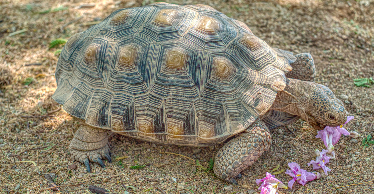
Some of the site’s most closely watched residents are desert tortoises, a species listed as threatened under U.S. law. Across much of the Mojave Desert, tortoises face pressure from roads, development, off‑road recreation, and disease. Within the Nevada National Security Site, they occupy large, relatively undisturbed areas with minimal day‑to‑day human contact. Biologists monitor their populations, mark burrows, and adjust ground activities to avoid direct harm, turning parts of a once‑bombed training ground into comparatively safe habitat.
The presence of apex predators underscores the system’s overall health. Mountain lions move through canyons and mountains in search of mule deer and bighorn sheep. Pronghorn and other hoofed mammals graze open flats. These larger animals require extensive territory, dependable water, and adequate forage. Their continued use of the site signals a functioning food chain that extends from the smallest insects and shrubs up to top predators.
Just a short drive away, the Las Vegas Valley has filled with neighborhoods, freeways, and commercial corridors, displacing native plants and wildlife. In stark contrast, the security perimeter around the test site has blocked large‑scale construction, preserving one of the region’s largest intact desert landscapes.
Science in a Closed Landscape
In 1987, federal scientists established a formal ecological monitoring program on the site. Since then, field teams have recorded plant cover, reptile and bird distributions, and populations of small and large mammals year after year. They map where species occur, measure changes over time, and track how vegetation rebounds on previously disturbed ground. This systematic record provides a rare, decades‑long view of desert recovery and resilience.
Modern tools have allowed researchers to reduce disturbance while expanding what they can see. Motion‑activated cameras document bighorn sheep, coyotes, and mountain lions, often at night. Some animals are fitted with GPS collars to reveal migration pathways and home ranges. Detailed vegetation surveys chart plant communities and highlight new growth in old blast zones or other disturbed areas.
Radiation from past nuclear tests persists in certain soils and subsurface zones, and craters remain visible in parts of the landscape. Yet plants now root in many of these areas, and animals move through them as part of their daily routines. Some species avoid the harshest sites, while others use crater rims and irregular ground as shelter. Field observations so far point to wildlife populations that are able to live, breed, and remain stable despite the remaining contamination.
Beyond the Fence

Because the public cannot freely enter the Nevada National Security Site, most people encounter its story through institutions such as the National Atomic Testing Museum in Las Vegas. Exhibits there outline the history of nuclear testing and increasingly highlight the ecological dimension: the way plants and animals have reclaimed ground once associated almost entirely with weapons.
The site has also become a key field location for radioecology, the study of how radiation interacts with living systems over long periods. Data gathered in Nevada help scientists interpret the aftermath of nuclear accidents elsewhere, including Fukushima in Japan and Chernobyl in Ukraine. By comparing radiation doses, species responses, and recovery rates, researchers can identify which habitats rebound quickly, which remain under stress, and how to better guide cleanup or conservation decisions.
Popular imagination often portrays nuclear landscapes as realms of obvious mutations and monstrous wildlife. Studies on the Nevada site, however, describe mostly normal‑appearing plants and animals, with any subtle genetic or health effects far less dramatic than fiction suggests. Researchers emphasize that the most significant factor shaping this ecosystem is not visible mutation but the near‑total absence of regular human activity.
The trajectory in Nevada echoes findings from the Chernobyl Exclusion Zone, where wolves, wild horses, and numerous bird species have returned as people have withdrawn. In both cases, radiation remains an important concern, but daily human pressure has sharply diminished. The shared lesson is that many wild species can recolonize damaged environments more quickly than expected when afforded space and time.
The Nevada National Security Site is still integral to U.S. defense and weapons stewardship, making it unlikely to become a recreation area. Even so, many scientists view it as a de facto wildlife reserve, and management plans increasingly acknowledge its role in safeguarding one of the West’s largest continuous desert habitats. Recent monitoring reports from 2023 and 2024 indicate stable or expanding populations for many key species and continuing vegetation recovery in long‑disturbed zones. The former proving ground now serves as a living case study in how life can push back into some of the harshest landscapes on Earth — and a reminder that decisions about where people do and do not tread will continue to shape the future of wild places.