Snow usually falls in the American South during winter. But January 2026 brought something much more dangerous. Over 17 million people faced severe weather alerts across seven states this weekend.
Meteorologists said the atmospheric conditions were “unseasonably aggressive” for the season. Tropical warmth and moisture collided with a powerful jet stream. This created a disaster waiting to happen. Major airports, roadways, and communities areprepared for impact.
Weather services issued their highest threat levels. The next 72 hours would challenge what people believed about winter weather and force millions to seek shelter.
Perfect Storm Pressure
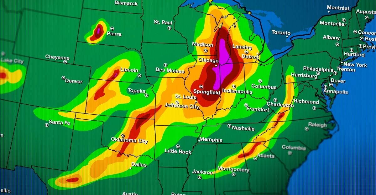
The weather setup looked like a textbook severe weather event. But January is not the season for this. A strong low-pressure system moved through the Midwest on January 8 and 9.
It dragged unseasonably warm air and record moisture north from the Gulf of Mexico. Rain fell at a rate of 3 inches per hour in southern Mississippi. That’s more like a summer hurricane than a January storm. A powerful upper-level jet stream and wind shear created rotation in storm clouds.
The Weather Prediction Center issued Level 2 and Level 3 threats. This placed tens of millions under tornado and flood watches simultaneously.
Tornado Season Off-Season

Tornadoes rarely occur in January. The U.S. averages just 39 tornadoes per month. They concentrate in the southern plains where Gulf warmth lingers. But January 2026 was different.
Seven confirmed tornadoes formed between January 8 and 10. Oklahoma had 4, Mississippi had 3, and Georgia had 1. These tornadoes packed the month’s expected tornado count into just 48 hours. The National Weather Service office in Norman, Oklahoma, sent damage survey teams.
They rated tornadoes using the Enhanced Fujita Scale. This process happens only for the most powerful storms. The first major tornado touched down Thursday morning in central Oklahoma near Purcell.
Racing the Clock

Communities had very little time to respond. Tornado warnings from local National Weather Service offices gave 10-15 minutes of advance notice. That’s the standard lead time, but it’s particularly tight for vulnerable individuals. Schools closed due to power outages before students arrived.
Interstate 35 near Purcell was shut down when high winds flipped a semi-truck. Mobile home parks in Mississippi activated emergency plans. Georgia residents saw alerts on social media about tornadoes near Atlanta. Meanwhile, Hartsfield-Jackson Atlanta International Airport prepared for a major operational crisis.
The weather system approached the metropolitan area. Flight schedules already faced disruption from the first storm wave. The second and most dangerous wave was expected to arrive on Saturday morning.
The EF-2 Judgment Call

Thursday, January 8, 2026, at 7:30 a.m., a radar-confirmed tornado ripped across Interstate 35 and Purcell, Oklahoma. The National Weather Service Norman Office first rated it as EF-1 with winds of 105-110 mph.
However, after crews completed their assessment on Friday, they upgraded the rating to EF-2. Peak winds reached 111 to 115 mph. The path measured 9.4 miles long and 100 yards wide. This single tornado was the most powerful of the entire outbreak.
The NWS said “one home about 3 miles southwest of Purcell had the roof removed.” About nine houses experienced roof damage. Metal barns and outbuildings were destroyed. No one died—a fact residents called miraculous.
The Power Grid Darkens
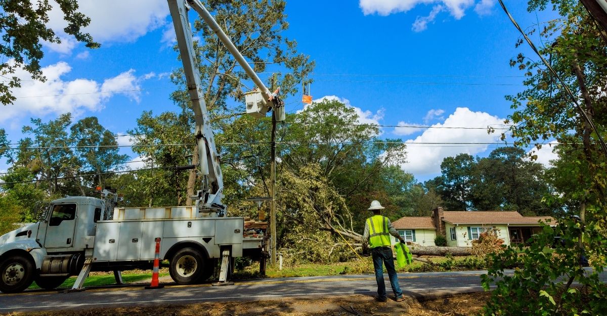
After the tornado, Purcell’s infrastructure faced a crisis. About 4,000 customers lost power when utility poles snapped, and transformers failed. The utility crews from the City of Purcell, Edmond, and Stillwater worked together.
They restored electricity through Thursday afternoon and into Friday. Purcell Public Schools announced two schools would stay closed due to power outages. This left families without basic services and disrupted childcare for working parents.
Police Chief Bobby Elmore coordinated the emergency response. He made utilities restoration his top priority. Gas leaks appeared in damaged areas, needing hazmat teams. The city’s water system experienced pressure drops due to broken pipes. A truck driver on I-35 got minor injuries when the wind flipped his semi.
Voices from the Wreckage

“I heard all the commotion,” Clinton Beaver said about when the EF-2 hit his newly bought Purcell home. “I felt a big amount of pressure on me, lifting me up. That’s when the roof gave way, and debris started falling.” His spouse heard the noise and ran in to find that the ceiling had caved in.
Debris covered everything. “We’re grateful to be safe,” they said later. “Our animals are all safe, too.” Another family surveyed debris in their new neighborhood. “We just moved in October and tried to settle in, and then this happens.”
The tornado struck at 7:30 a.m. when many residents were still home. Survival depended on quick decisions and a bit of luck. But Purcell received one blessing: no deaths.
Mississippi’s Secondary Wave

While Oklahoma recovered Friday, Mississippi faced its own tornado outbreak. Three confirmed tornadoes touched down in Mississippi on January 9-10. Two were EF-1 tornadoes in Walthall/Marion and Madison/Leake counties. One was EF-0 in central Mississippi.
The EF-1 near Tylertown uprooted trees, damaged roofs, and destroyed a restaurant. An EF-0 near Ofahoma downed power lines and snapped trees near the Natchez Trace Parkway. But the real danger in Mississippi was flooding, not tornadoes.
Rain fell at 3 inches per hour. Training thunderstorms (storms moving sideways over areas) dumped 5-8 inches of rain in southern Mississippi within 24 hours. Flash flood watches were in effect for Louisiana, Mississippi, and Alabama. The Weather Prediction Center issued a Level 3 out of 4 flood threat.
Atlanta’s Crossroads
By Saturday, January 10, the weather system moved east toward the Southeast’s most important transportation hub. Georgia confirmed one EF-1 tornado in Carroll County. It damaged barns and homes along Liberty Church Road and Staples Dairy Road. Wind speeds reached 95 mph.
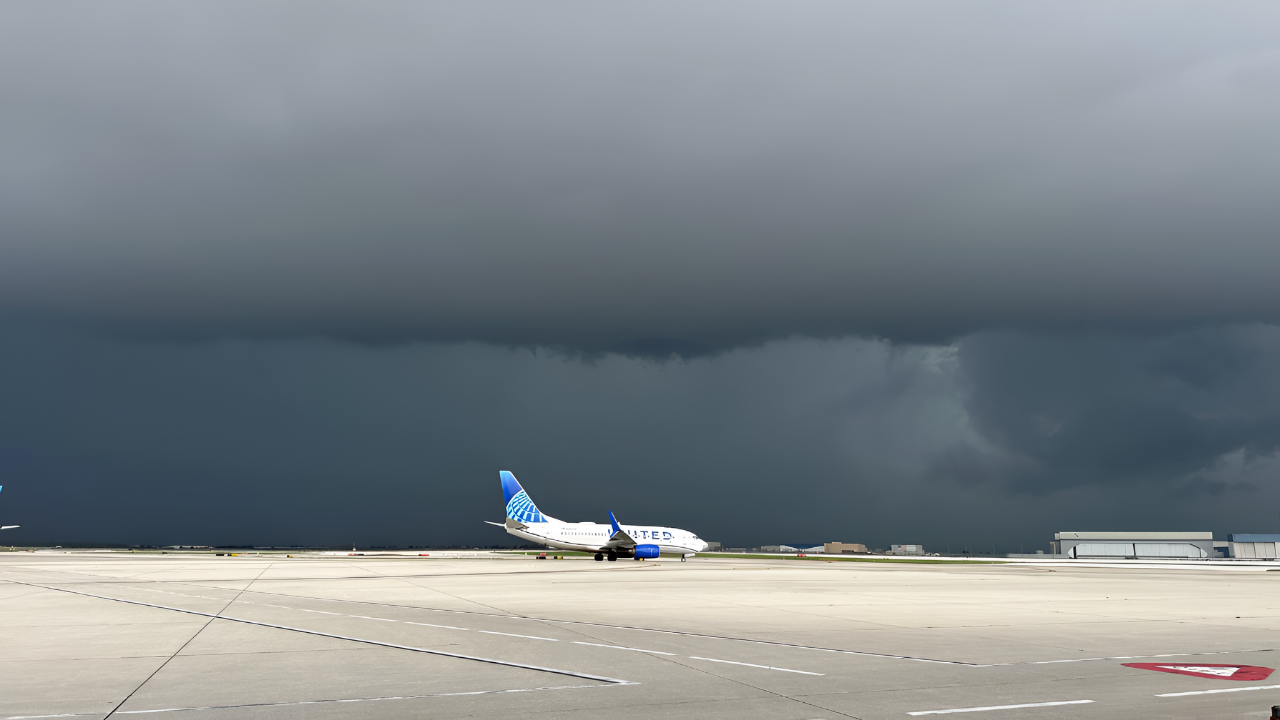
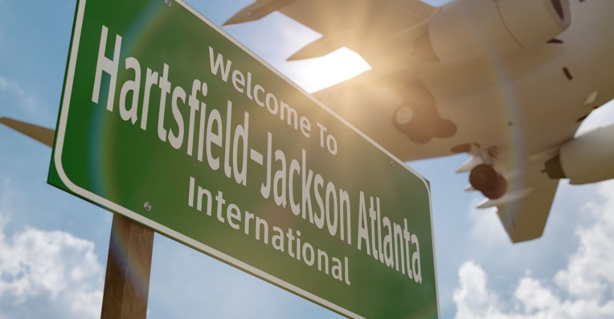
That was strong enough to destroy farm buildings, but it was below the EF-2 level. Radar showed multiple tornado signatures approaching the Atlanta metro area. Residents took shelter. But the bigger story happened at Hartsfield-Jackson Atlanta International Airport.
This is the world’s busiest aviation hub in terms of passenger volume. It handled 108.1 million passengers in 2024. The FAA issued a ground stop for all inbound and outbound traffic on Saturday morning. Severe thunderstorms with tornado warnings approached the airport. Flight operations halted temporarily. Thousands of travelers found themselves stranded at gates and terminals.
The Winter Anomaly Pattern

Weather scientists saw a deeper problem. January 2026 showed a destabilizing climate pattern. Normal January weather is scattered and stays in one region. This outbreak demonstrated sustained instability spanning over 1,000 miles from Oklahoma to Georgia. It lasted over 72 hours.
The tropical moisture, warm air, and jet-stream position matched what meteorologists expect in May or June. The Weather Prediction Center issued Level 2 and Level 3 threats across the same area. These applied to BOTH tornadoes and flooding at the same time. This rare combination suggested systemic instability, not just one storm.
The NOAA Weather Prediction Center warned of “multiple rounds of severe weather” through Saturday night, January 11. This was a sprawling, organized system. Meteorologists projected that it could produce additional tornadoes and widespread flooding for 48 hours or more.
The Airport Nightmare Intensifies
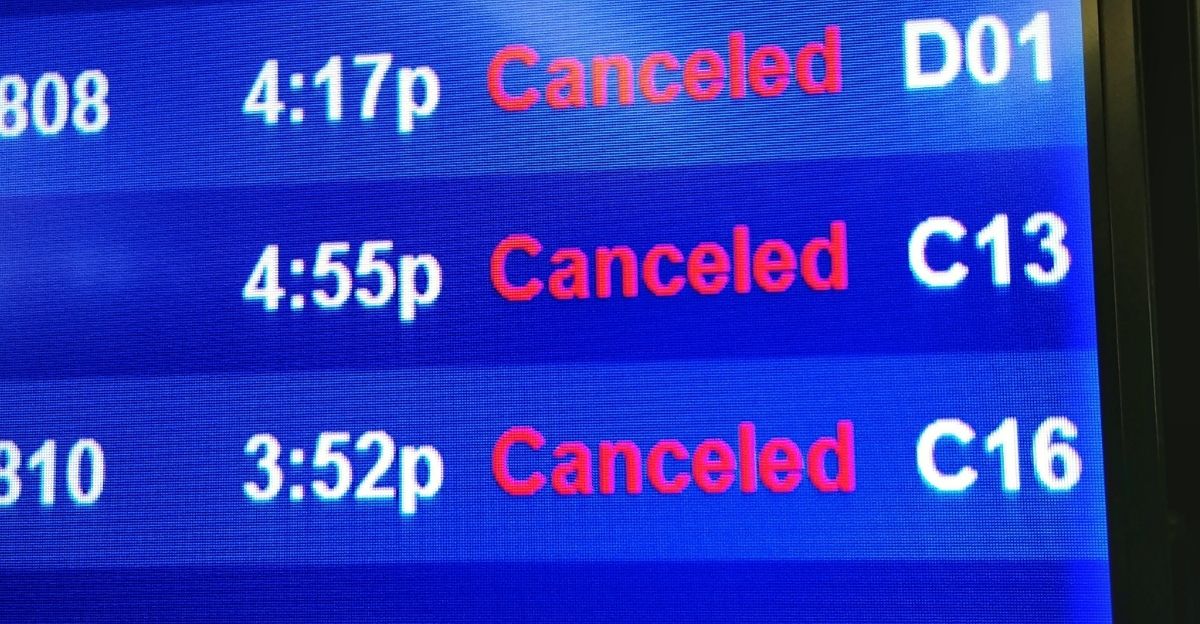
Stranded passengers at Hartsfield-Jackson experienced one of the worst travel days ever. By mid-Friday (January 10), the airport issued a ground stop. It canceled more than 1,200 flights. FOX 5 journalist Matt Stringer got stuck at the airport early in the morning.
He described boarding, unboarding, and re-boarding, then learning his flight was canceled. He waited 15 hours in uncertainty. His colleague, Tyler Fingert, arrived at 4 a.m. for a 6 a.m. flight. It was delayed until 2 p.m., then the airline canceled it entirely.
“There’s only so much time pilots and flight attendants can work,” Fingert said. “When that time runs out, flights get canceled unless extra crews are available.” The FAA extended the ground stop throughout the day. By late Friday, over 2,600 flights nationwide were canceled.
A Delta Evacuation Crisis
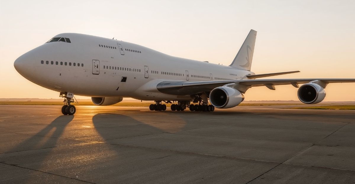
At about 9:10 a.m. on January 10, Delta Flight 2668 aborted takeoff. This Boeing 757 carried 201 passengers and 7 crew members bound for Minneapolis-St. Paul. Pilots suspended takeoff due to “an indication of an engine issue.” The flight had already faced delays due to the ground stop.
Emergency crew deployed evacuation slides. Passengers evacuated onto the tarmac in panic. The airport’s operations center declared the aircraft a hazard. Four passengers got minor injuries during evacuation. One person went to a hospital. Three received treatment on-site.
The FAA launched an investigation into the engine problem. The incident further jammed airport operations. It consumed runway space and ground crew resources during peak morning hours. Video captured evacuation slides deploying as snow piled up. But the engine issue may not be related to the weather.
Cascading Systems Failure

The cascade of failures demonstrated the interconnectedness of modern transportation. Canceling over 1,200 flights at Atlanta meant crews were stranded in other cities. These flights leave the next day. Hotels filled within hours. Airlines issued fare-difference waivers allowing rebooking.
But alternative flights were already full. Delta canceled approximately 500 of its own flights, as well as connections. The airline said all five runways were closed by mid-morning. This created gridlock on the ground. Ground crews struggled to de-ice planes while wet snow continued to fall.
The airport’s road access also faced disruption. Icy conditions made ground transportation to the terminal unreliable. The airport issued winter protocols. But time was what travelers didn’t have. By late Friday, the FAA reported delays exceeding 10,900 flights nationwide.
Expert Assessment: Questions Linger
Meteorologists puzzled over January’s pattern. The American Meteorological Society noted that warm-season moisture intrusions in winter are becoming more frequent. But they remain rare enough to surprise veteran forecasters. “We saw tropical precipitable water values—more typical of June—in January,” one NWS meteorologist said. The question was why.
Some blamed El Niño conditions and warmer-than-normal ocean temperatures. Others cited wind pattern anomalies that pushed the jet stream farther south. The Climate Prediction Center noted that January 2026 had above-normal temperatures across the southeastern United States.
Anomalous moisture transport came from the Gulf. These conditions are associated with an increased potential for severe weather. However, skepticism remained about whether this showed a long-term climate shift. Or was it simply an isolated event? February and March forecasts showed no indication of repeating the pattern.
The Reckoning Ahead

By Sunday, January 12, the weather system exited to the Atlantic. Skies cleared over Oklahoma, Mississippi, Georgia, and the Southeast. Hartsfield-Jackson resumed normal operations. Travelers rebooking flights faced capacity constraints and premium fares.
Purcell residents began the lengthy process of filing homeowner insurance claims and rebuilding. Mississippi prepared for flood cleanup as swollen rivers reached their peak. Purcell officials confirmed no deaths. They called the outcome “miraculous.”
The EF-2 had struck a populated area at 7:30 a.m. when residents could have been commuting on I-35. The National Weather Service released preliminary findings. They confirmed seven tornadoes and unprecedented January weather dynamics. Federal emergency managers started damage assessments. Airlines tallied losses from 2,600+ canceled flights. Families without power for 48+ hours documented damage for insurance.
Sources:
- National Weather Service Norman Office, Damage Assessment and Tornado Ratings, January 9, 2026
- Fox 5 Atlanta, Severe Weather Coverage and Airport Disruptions, January 7-10, 2026
- NOAA Weather Prediction Center, Severe Weather Threat Bulletins, January 6-11, 2026
- FAA Ground Stop Data, Hartsfield-Jackson Atlanta Airport Operations, January 10, 2026
- New York Times Weather, Sprawling Storm System Coverage, January 8, 2026
- Delta Air Lines Statement, Flight Cancellations and Emergency Response, January 10, 2026