The Skagit River kept rising through the night, pressing against levees and floodwalls as downtown Mount Vernon fell silent under evacuation orders. With the river forecast to crest higher than ever recorded, local officials warned that defenses designed for past storms might not withstand this surge, driven by days of unrelenting rain and a powerful atmospheric river over Western Washington.
Why The Water Rose So Quickly

Meteorologists say an atmospheric river is funneling exceptional amounts of Pacific moisture into the region, dumping sustained heavy rain over the Skagit basin. Already running high, the river is now expected to crest several feet above previous records, raising the prospect that levees and Mount Vernon’s metal floodwall could be overtopped.
Communities such as Mount Vernon and Concrete are bracing for what could be their most severe inundation in decades, with projected water levels surpassing earlier benchmarks by a wide margin. Officials describe the situation as a worst-case combination of saturated ground, persistent downpours, and constrained floodplains.
Communities on the Move

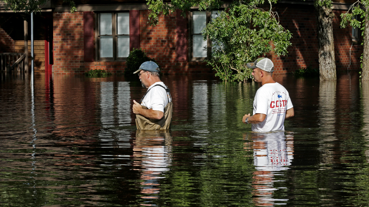
More than 75,000 people living along the Skagit River corridor have been told to leave, with roughly 15,000 in the most vulnerable floodplain zones ordered to evacuate immediately. Families have packed cars with essentials, sought space in shelters or with relatives, and tried to maintain contact with elderly neighbors as routines collapsed in a matter of hours.
For many residents, this is the first time they have been forced out by water, and the scale of the evacuation has tested local shelter capacity from Burlington south toward Everett. Hotels and emergency centers are filling quickly as American Red Cross facilities report unusually high numbers of families arriving at once, often unsure when they will be able to return home.
Farmers in the Skagit floodplain are working nonstop to move livestock, feed, and machinery to higher ground, mindful of the losses suffered in previous major floods. Memories of the 2021 disaster are shaping how quickly people act, but many say current conditions already feel beyond what they had imagined possible.
Economic Shockwaves and Strained Systems

As residents flee, downtown Mount Vernon business owners are hauling inventory upstairs and boarding up storefronts, hoping the city’s floodwall will buy time. Forecasts that the barrier may be overtopped have left retailers, warehouses, and farm supply outlets anticipating serious damage during a crucial pre-holiday period.
Across the valley, the financial effects are spreading. The value of houses near the river is under pressure as repeated evacuations reshape buyer interest and expectations. Real estate agents anticipate that properties in known flood zones will face declining demand, while insurance costs rise or coverage becomes harder to secure. With extreme floods now occurring far more often than the “once-in-a-century” label suggests, analysts warn that some insurers may limit their exposure in high-risk river communities.
The broader regional economy is also feeling the strain. Flooded roads in Skagit County and adjoining areas are disrupting freight along the Interstate 5 corridor, one of the main trade arteries between Canada and the United States. Trucking companies are dealing with detours, higher fuel use, and missed delivery windows, with knock-on effects for firms that depend on tight shipping schedules.
Local stores have shifted quickly to focus on emergency supplies such as generators, sandbags, and bottled water. Grocery outlets are balancing surging demand with delayed deliveries, trying to keep basics available for those still in place and for evacuees passing through.
Critical infrastructure is under close watch as water climbs around levees in Snohomish, Pierce, and Lewis counties. Utilities are monitoring wastewater plants, power substations, and other key facilities, aware that overtopping or seepage could trigger outages or contaminate drinking water. Hydrologists warn the Skagit could rise another 8 to 10 feet within a day, with levels near the town of Concrete potentially jumping by up to 20 feet in the same window.
Climate Pressures and Unequal Impacts
Washington Governor Bob Ferguson has declared a state of emergency, activating additional state resources and coordination through the Washington Military Department. Officials are preparing more shelters, moving sandbags into threatened neighborhoods, and planning door-to-door checks if levees weaken. The economic toll from damage to homes, farmland, and infrastructure is already expected to reach into the billions of dollars, with costs continuing long after the water recedes.
Health concerns are mounting as well. When floodwater seeps into buildings, it can carry sewage, industrial chemicals, and fuel, leaving behind contamination and mold. Repeated evacuations and uncertainty are taking a psychological toll, contributing to stress, anxiety, and depression, particularly among older residents and low-income households with fewer options for relocation or rebuilding.
Scientists and ecologists point to a longer-term pattern behind the immediate crisis. What was once considered a 100-year flood on the Skagit now appears roughly every two to three decades. At the same time, at least half of the river’s original floodplain has been lost to development, removing natural storage areas that once slowed and spread out high flows. That combination of a warming climate and diminished floodplain has amplified the severity of recent events.
A Glimpse of the Future for River Cities
The Skagit Valley’s ordeal is being watched far beyond Washington state. Recent catastrophic floods in places such as Germany, Pakistan, and British Columbia have shown how river systems can overwhelm aging levees and dams when pushed by extreme rainfall and narrowed channels. As institutional investors reassess the risks facing utilities, real estate, and insurers in low-lying areas, companies focused on resilience and disaster response say they are seeing more interest in solutions that can withstand recurring floods.
Locally, planners are examining options such as setback levees and expanded floodways to give the river more room during peak flows. Residents across Western Washington are being urged to heed evacuation orders, avoid driving on levees and dikes, assemble emergency kits, and stay tuned to National Weather Service alerts as atmospheric rivers become more common.
For now, the priority remains getting people out of harm’s way and protecting vital systems. But as the Skagit approaches record levels, the region is also confronting a larger question: how to adapt homes, farms, infrastructure, and financial systems to a future in which extreme river floods are no longer rare, but a recurring test of resilience.
Sources:
“Skagit County Emergency Alert: Stay Informed and Prepare for Potential Evacuations.” Skagit County Government, 9 Dec 2025.
“2025 Pacific Northwest floods.” Wikipedia, 7 Dec 2025.
“Go Now: 100,000 Evacuated in Historic Skagit Flood.” KUOW, 10 Dec 2025.
“Pacific Moisture Drenches the U.S. Northwest.” NASA Earth Observatory, 12 Dec 2025.