The sky over western Washington and northwest Oregon turned dangerous in a matter of hours. By the night of December 11, 2025, days of warm, moisture-rich air had driven rivers toward historic crests, triggering urgent flood warnings and sweeping evacuations. Major waterways, including the Snoqualmie, Skagit, Stillaguamish, and Snohomish, surged to near-record and record levels, cutting off communities, closing highways, and forcing thousands from their homes as emergency crews raced to keep pace with rapidly rising water.
Atmospheric River Unleashes Rapid Flooding

Forecasters traced the crisis to a powerful atmospheric river, a narrow band of warm, moisture-laden air that parked over the Pacific Northwest. The prolonged downpours saturated soils and funneled extraordinary volumes of runoff into river systems already running high. Within roughly 24 hours, several rivers jumped from high flow to near-record and record flood levels.
On the Stillaguamish River at Arlington, the water was forecast to reach about 24 feet, exceeding the previous record of 21.3 feet. Major rivers commonly associated with winter flooding in the region—the Stillaguamish, Snoqualmie, and Skagit—were all pushed toward thresholds that strain levees, inundate low-lying neighborhoods, and threaten critical infrastructure. The timing, just before the year-end holidays, left many residents with little opportunity to secure belongings or fortify homes.
Near-Record and Record Crests Across Multiple Rivers

Hydrologists with the National Weather Service projected exceptional flows across the region. On the Snoqualmie River near Snoqualmie Falls, discharge was expected to reach approximately 45,000 cubic feet per second, a level associated with severe flooding downstream through communities such as Fall City. Along the Snohomish River, gauges near Monroe were forecast to crest within inches of the historical record at nearly 25 feet, while the river at Snohomish itself was expected to reach approximately 33.8 feet Thursday evening, exceeding the previous record of 33.5 feet.
Farther north, the Skagit River near Mount Vernon was projected to crest near 39 to 41 feet by Friday morning, putting farmland, homes, and transportation routes at risk. Other waterways were also under pressure: the Skykomish River near Gold Bar was forecast to reach approximately 23 feet, enough to send water into homes and across agricultural land. Forecasts for the Cowlitz River at Randle called for a crest near 24 feet, and the Cedar River near Renton reached record-breaking levels, raising the prospect of major flooding at the Renton airport and nearby neighborhoods.
Evacuations, Road Closures, and Local Disruptions
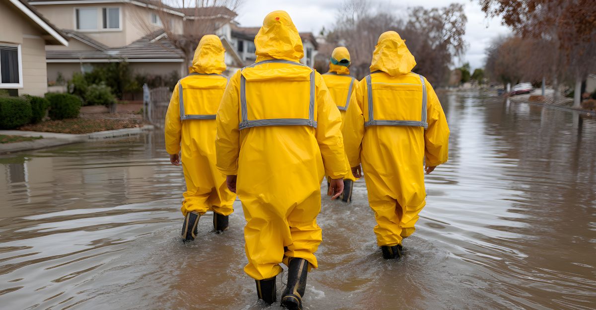
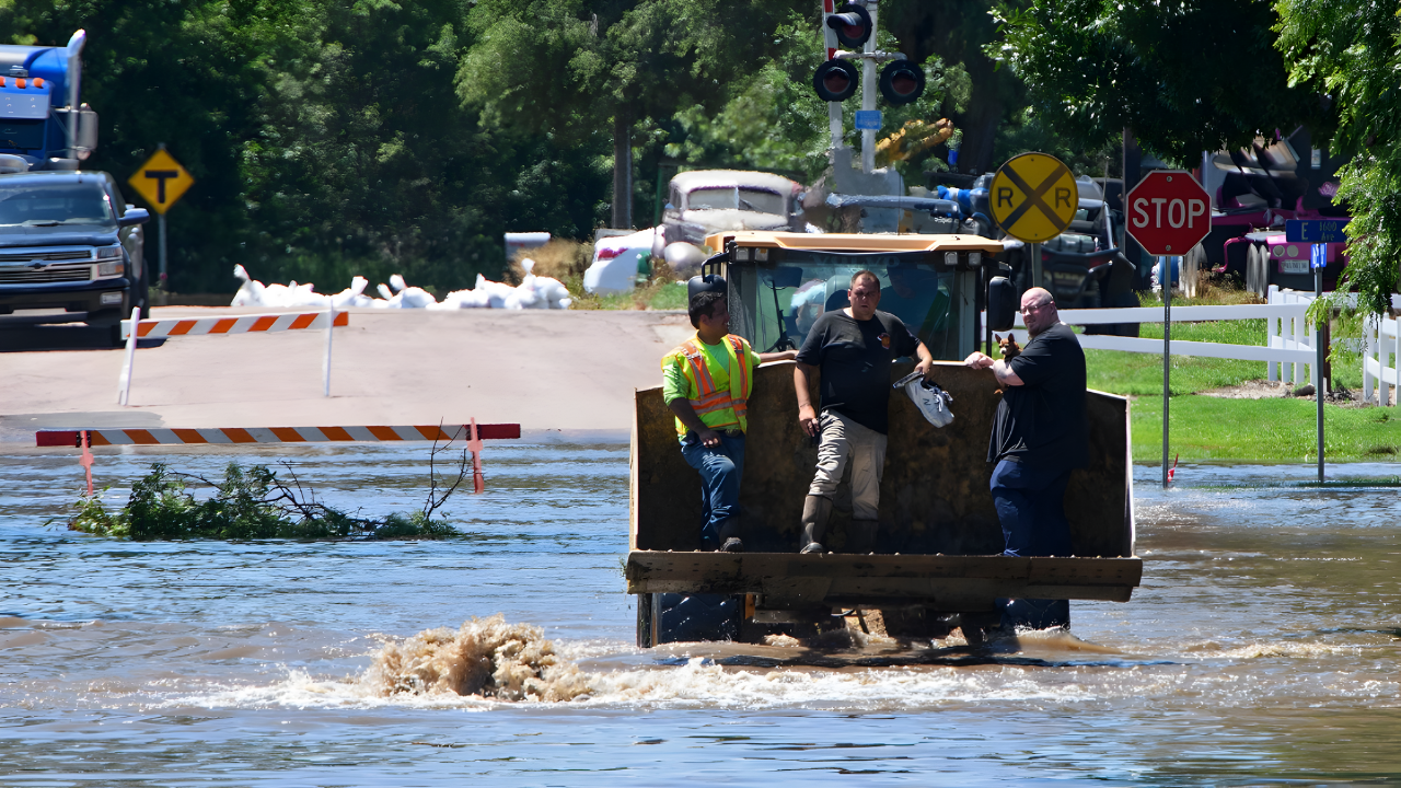
As rivers climbed, local officials in Snohomish, Skagit, King, and Lewis counties ordered evacuations in flood-prone zones. More than 75,000 residents in Skagit County alone were advised to evacuate, with approximately 100,000 residents across the region facing evacuation orders. Residents in places such as Arlington, Carnation, and Randle moved to emergency shelters or stayed with relatives and friends. Swiftwater rescues were reported after vehicles stalled in rising waters, underscoring the danger of trying to drive through flooded streets.
Transportation corridors across the region were hit hard. Highway 530 and Highway 12 became impassable where river water spilled over the pavement. Valley roads between Interstate 5 and Stanwood were cut off, isolating some homes and farms. Secondary roads that often serve as alternate routes were also submerged, complicating access for ambulances, fire crews, and search-and-rescue teams.
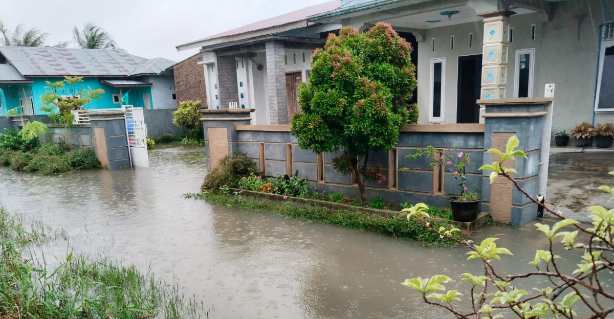
The impacts stretched beyond immediate safety risks. Closed roads and flooded neighborhoods disrupted work schedules, school operations, and medical appointments throughout western Washington and northwest Oregon. In some communities, medical facilities in at-risk areas prepared contingency plans in case they, too, had to evacuate staff and patients.
Economic Strain on Farms, Freight, and Infrastructure
The flooding carried significant economic consequences for agriculture and trade. Farmers along the Skagit and Snohomish river valleys saw fields, livestock areas, and storage buildings inundated. Crop losses and damage to equipment threatened to linger long after the waters recede. Many small-town businesses shut their doors temporarily, cutting off income for workers who depend on hourly wages.
Freight movement between major urban centers such as Seattle, Everett, and Bellingham slowed as trucks were forced onto longer detours or idled while key routes were underwater. With feeder roads to ports and rail yards closed, shipments of essential goods to and from the ports of Seattle and Tacoma were delayed, disrupting both imports and exports at the height of the pre-holiday shipping period. Officials warned that consumers could see higher prices and sparser shelves as produce distribution and other supply chains absorbed the shock.
At the same time, the physical toll on public infrastructure mounted. State transportation agencies anticipated costly repairs to damaged bridges, eroded embankments, and compromised roadbeds. Utilities monitored systems for washouts and failures in areas where floodwaters scoured banks and saturated ground around poles, pipelines, and buried cables.
Warnings, Emergency Declarations, and Future Risks
Authorities emphasized safety as the crisis deepened. The National Weather Service reminded residents that even relatively shallow, fast-moving water can be deadly, noting that six inches of swift flow can knock over a person and two feet is enough to float a car. Officials urged people not to walk, swim, or drive through floodwaters, and to follow evacuation orders and posted detours.
Washington Governor Bob Ferguson declared a state of emergency as forecasters signaled that as many as 100,000 residents could face evacuation orders if the atmospheric river continued to feed intense rainfall. Emergency management teams across multiple counties coordinated shelter operations, sandbagging, and public communication.
By December 11, multiple rivers beyond the early focal points were at major or moderate flood stage, including the Puyallup River near Orting, forecast to reach major flood levels; the Skookumchuck River near Bucoda, expected to rise near 214 feet and flood homes and roads; and the South Fork Nooksack River at Saxon Bridge, where residents in Acme were warned to expect flooding affecting farms, homes, and transportation routes. In several basins, elevated water levels were expected to persist into the weekend, delaying damage assessments.
As atmospheric river events become more frequent in a warming climate, officials and residents in flood-prone communities face mounting pressure to strengthen defenses. Emergency planners encourage households to review evacuation routes, maintain go-bags with essentials, safeguard important documents, and consider flood insurance where available. Local and state leaders are being pushed to invest in levees, floodplain restoration, and land-use decisions that reduce exposure. The current flooding, with its mix of human hardship, infrastructure strain, and economic disruption, is likely to shape how the Pacific Northwest prepares for the next powerful storm system that sweeps in from the Pacific.
Sources
National Weather Service Flood Warning Summary. National Weather Service, 11 Dec 2025.
Washington State Braces for Dangerous Flooding as Thousands Could Face Evacuation Orders. CBS News, 11 Dec 2025.
Catastrophic Pacific Northwest Floods Leaves 100,000 Facing Evacuation. NBC News, 11 Dec 2025.
Live: Flooding in WA’s Skagit, Snohomish Rivers Prompt Evacuations and Road Closures. The Seattle Times, 11 Dec 2025.