A sudden flood is taking shape across the Pacific Northwest as a powerful atmospheric river has already dumped 8 to 10 inches of rain in just two days. The relentless downpour continues with predictions of another 4 to 8 inches through Thursday, pushing rivers in four states toward critical flood levels.
Officials are sounding the alarm as this storm threatens to become one of the region’s most widespread and destructive floods in recent memory. How high will the water rise?
Rising Threat

Forecasters have classified this atmospheric river as a Level 4 of 5, one of the strongest storm categories. The storm, a steady plume of moisture, is drenching the Cascades, Olympics, and coastal ranges, creating a heavy rain band visible from space.
With over 20 river flood warnings across multiple basins, some rivers may not peak until days after the rain ends. What happens when saturated slopes and swollen rivers collide?
Atmospheric Rivers Explained

Atmospheric rivers are narrow but powerful channels of moisture-laden air that carry roughly the equivalent amount of water as the Mississippi River—but high above the ground. When these rivers stall over mountainous terrain, they release intense, sustained rain.
The Pacific Northwest experiences several atmospheric rivers every winter, but this one’s strength and timing have created a rare, highly dangerous flood threat.
Drought Meets Deluge

Ironically, months of drought in the Pacific Northwest have worsened the impact of this storm. Drought-hardened soils can’t absorb the massive rainfall, causing swift runoff into rivers.
The result: rapid river rises and widespread flooding, much worse than in a typical wet year. Rivers are surging toward major flood stages, amplifying risks for downstream communities.
Record Crest Threats

The Snohomish River is forecast to crest at 32 feet Thursday, approaching its record of 33.5 feet. The Skagit River is also expected to rise well above its historical high, possibly 3 to 5 feet higher than previous records.
Thirty-four river gauges are at risk of reaching major flood stage, with 18 forecast to reach major flood levels—setting the stage for one of the most significant flooding events in years.
Four States Affected

The flood’s reach stretches across four states: Washington, Oregon, Idaho, and Montana. Western Washington faces the heaviest flooding, with several rivers nearing or approaching record levels.
Northwest Oregon is also in major flood danger, particularly along the I-5 corridor. Meanwhile, northern Idaho and western Montana face additional hazards from heavy snow and avalanche warnings.
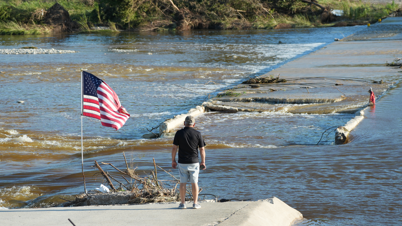
Lives at Risk

Already, the flooding has led to rescues along the I-5 corridor between Portland and Seattle, where rapidly rising waters have trapped drivers. In Washington’s coastal counties, rivers like the Grays and Naselle are threatening homes and farmland, with the Grays River reaching 33.36 feet and the Naselle approaching its record level.
The situation has escalated to the point where mudslides and flooded roads are making evacuation efforts difficult.
Emergency Declarations

In response to the disaster, Washington state has declared a statewide emergency, unlocking state resources for recovery and response. Local jurisdictions, including King County, Snohomish County, and the City of Snohomish, have issued emergency proclamations of their own, signaling the severity of the situation.
These declarations help expedite aid and resources as the storm continues.
Colliding Impacts

The storm’s impact is not confined to one area. Multiple rivers in western Washington are cresting at once, including the Snohomish and Skagit, creating a massive flood event.
With landslides and avalanches adding to the danger, communities are facing an all-out assault of simultaneous hazards that complicate emergency responses and damage assessments.
Strain on Infrastructure

Critical infrastructure is buckling under the strain of flooding. Mudslides have closed roads in the Cascades and Columbia Gorge, and local flooding is disrupting evacuations and emergency access.
Power and communication lines are vulnerable to inundation, leaving communities with limited access to vital services. The cumulative toll is exacerbated by the storm’s growing frequency and intensity.
Frustration on the Ground

Locals are growing frustrated as floods continue to hit, straining both their patience and finances. Many residents are left grappling with the decision to rebuild in flood-prone areas, elevate their homes, or relocate entirely.
Property values and insurance premiums are shifting dramatically, creating economic uncertainty in the wake of this storm.
Leadership Under Pressure

As the floodwaters rise, local, state, and federal leaders are facing pressure to act quickly and effectively. While emergency declarations streamline access to resources, officials at all levels must make critical decisions about evacuations, shelter openings, and road closures.
Public trust is on the line as each decision is scrutinized, and the clock is ticking before the storm’s full impact is felt.
Preparing for the Future

In the aftermath, the Pacific Northwest will need to rethink its flood prevention strategies. Discussions will center around improving floodplain management, reinforcing levees, and revising building codes for flood-prone areas.
Local governments will also seek federal and state funding to address the increasing risks posed by such extreme weather events.
Experts Sound the Alarm

Experts warn that rising ocean temperatures and shifting atmospheric patterns are intensifying atmospheric rivers, making these storms more frequent and severe. Hydrologists are calling for better forecasting, improved river monitoring systems, and updated flood maps to protect vulnerable communities.
The question remains: how much more will these systems need to evolve to meet the new normal?
Looking Ahead

As the storm subsides, attention will shift from immediate disaster relief to long-term recovery and adaptation. With rivers at or near record levels and communities in four states reeling, the Pacific Northwest faces an urgent question:
How will it adapt to the growing threat of more severe, more frequent flooding in the years to come? The future of infrastructure and emergency planning may be in the balance.
Sources:
Governor of Washington Official Statement
State of Washington Governor’s Office, December 9, 2025
AccuWeather Meteorological Analysis
AccuWeather, December 9-10, 2025
Seattle Times Weather Coverage
Seattle Times, December 9, 2025
2025 Pacific Northwest Floods Reference
Wikipedia, December 10, 2025
Ground News Aggregated Report
Ground News, December 10, 2025
Center for Western Weather and Extremes (Scripps/UCSD)
CW3E, December 8, 2025