The rain starts coming down in sheets, soaking Portland’s streets in a matter of hours. By Wednesday morning, creeks have swollen, and floodwaters lap at the doorsteps of homes in low-lying neighborhoods.
Emergency sirens wail in the distance, and the sound of water rushing through streets grows louder by the minute. Portland residents are bracing for what could be one of the most destructive storms of the year, as an atmospheric river takes hold.
Why the Storm Is Dangerous

This storm is drawing deep moisture into northwest Oregon, triggering significant rainfall. Strong winds, saturated soils, and high snow levels around 6,000 feet make the situation even more dangerous.
The risk of flooding and landslides increases as runoff from the rain overwhelms creeks and streams, particularly around the Willamette River and other local waterways.
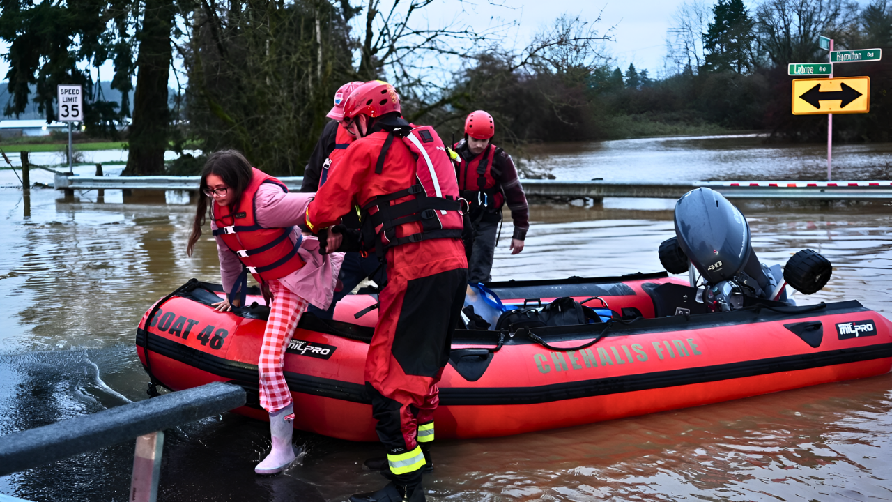
Flood Risks in Portland

In Portland’s low-lying areas, localized flooding is a real threat. Neighborhoods along creeks such as Johnson Creek are especially vulnerable.
Those living near steep slopes are also at risk of landslides. The NWS’s flood watch extends through Friday morning, urging residents to stay alert as conditions worsen over the next 48 hours.
How Emergency Services Are Preparing

Portland’s emergency teams and utility companies are readying themselves for widespread power outages and infrastructure damage.
Crews are staging equipment in anticipation of downed trees and high water. Emergency services are also monitoring rising river levels, with particular focus on Willamette River tributaries, ensuring rapid response to any sudden events.
Transportation Disruptions

Flooding and potential landslides pose a serious threat to roads and highways in the Portland area. Local authorities are warning drivers to avoid flood-prone areas and low-water crossings.
Public transportation services are on alert and could adjust routes to avoid blocked roads, ensuring safety and mobility as conditions evolve.
Waterways and Infrastructure Under Strain

Urban creeks and streams are expected to rise quickly, particularly in the Coast Range and Cascades foothills.
Minor flooding is likely on tributaries of the Willamette River. Infrastructure such as culverts, storm drains, and bridges may face stress from heavy rainfall, leading to potential blockages or overflows.
Landslide-Prone Areas at Risk

Residents in landslide-prone areas of Portland are on high alert. Local governments are distributing sandbags to homeowners to protect properties.
As the storm worsens, the risk of sliding debris increases, making this a critical period for homeowners in these vulnerable zones to take precautions.
Local Government and State Response

Local authorities have activated emergency operations centers, working closely with state agencies to coordinate response efforts.
Officials are pushing for community awareness, urging Portland residents to review their evacuation plans. The priority remains protecting lives and minimizing damage from flooding and landslides.
Economic and Insurance Impacts

Businesses in flood-prone areas face disruption, especially those in low-lying zones. Insurance companies are bracing for a rise in claims related to flood and landslide damage.
The financial burden of response and recovery could strain local disaster relief budgets, putting pressure on the region’s ability to respond effectively.
Health and Safety Precautions

Health experts are advising residents to avoid contact with floodwaters, which could carry contaminants.
Those with respiratory conditions should remain cautious about potential mold growth, which could spread in homes affected by water damage. Emergency kits, along with evacuation plans, are essential for all families, particularly in high-risk areas.
Environmental Impact and Climate Change

The atmospheric river highlights how saturated soils and high snow levels can create rapid runoff, leading to flooding.
Climate scientists have pointed out that atmospheric rivers are intensifying, with more frequent extreme weather events affecting infrastructure and land use. This storm raises questions about future preparedness in vulnerable areas.
Public Awareness and Preparedness

Portland residents are responding to the flood watch with caution, many stocking up on supplies and reviewing their emergency plans.
Social media and local news are playing a key role in disseminating the NWS’s warnings, helping spread crucial safety information and ensuring that residents are informed about the storm’s potential impact.
Winners and Losers

While the storm brings significant risks, some sectors are seeing short-term benefits. Sales of sandbags and emergency supplies are spiking, while weather forecasting services are in high demand.
On the other hand, outdoor events, tourism, and small businesses in flood zones face revenue losses as access is cut off or delayed.
Financial Guidance for Residents

For homeowners and renters in flood- and landslide-prone areas, reviewing insurance policies is crucial. Renters should also be aware of their building’s evacuation plans.
Everyone should ensure they have an emergency kit ready and stay updated with information from the local government and NWS alerts.
What’s Next for Portland

The heavy rain is expected to taper off by Thursday, with conditions slowly improving into the weekend. Officials continue to urge Portlanders to stay prepared, emphasizing that even low-probability extreme rainfall events can have widespread impacts.
The storm serves as a reminder of the importance of resilient infrastructure in the face of more intense weather.
Sources:
National Weather Service Portland December 2025 Flood Watch Statements; NOAA Weather Prediction Center Excessive Rainfall Outlook
Center for Western Weather and Water Extremes (CW3E) Atmospheric River Scale Analysis; USGS National Water Information System (Johnson Creek Hydrographs)
Portland Bureau of Transportation (PBOT) Severe Weather Travel Advisories; Multnomah County Emergency Management Alerts
Oregon Climate Change Research Institute (OCCRI) Assessments; IPCC Sixth Assessment Report (Regional Climate Trends)