The most powerful flooding in decades has turned communities across Washington into disaster zones, after a record-breaking atmospheric river drenched the state with days of intense rain and rapid snowmelt. Beginning December 8, 2025, the storm system pushed rivers from the Canadian border to southwest Washington above major flood stage, prompting Governor Bob Ferguson to declare a statewide emergency on December 10 as authorities raced to protect levees, move people to safety, and brace for more storms still in the forecast.
Rivers Rise, Residents Run
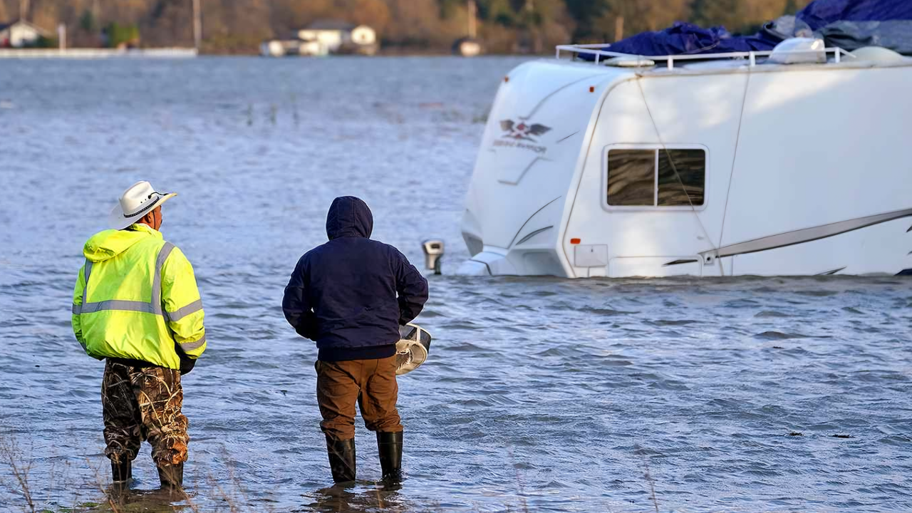
Within 48 hours, multiple river basins simultaneously surged into major flooding, swallowing roads, bridges, and thousands of homes from northwest Washington through the Cascades and into southwest counties. More than 75,000 residents in Skagit County alone were ordered to leave immediately as floodwaters spread through Burlington and parts of Mount Vernon, with statewide alerts eventually affecting around 100,000 people.
National Guard troops, more than 300 in all, deployed with high-water vehicles, helicopters, and sandbags to bolster levees and conduct rescues. Some isolated communities, such as Randle in Lewis County, waited hours for aircraft or ground help as mudslides and washed-out roads cut off access. Shelters opened rapidly around the state, with more than 20 facilities in cities including Mount Vernon, Burlington, and Leavenworth ultimately housing roughly 5,000 evacuees.
Local responders and volunteers ferried people from flooded homes, often guiding families carrying pets, medications, and a few belongings through chest-deep water. In places like Lewis County’s Randle and Packwood, rising flows on the Cowlitz River forced rescues from stranded vehicles and inundated neighborhoods twice as the river crested, receded, and rose again.
A Historic Atmospheric River

The flooding was driven by a particularly intense atmospheric river, a long, narrow plume of moisture often described by scientists as a “river in the sky.” This event, which began impacting the region on December 8, ranks among the strongest observed for the Puget Sound area, with forecasters calling for up to 10 inches of rain in higher elevations over just a few days.
Unusually warm air pushed snow levels above 7,000 feet, rapidly melting existing mountain snowpack and turning it into additional runoff funneled into already-swollen rivers. Western Washington locations recorded more than 7 inches of rain in 48 hours by December 9, with Olympia logging 3.03 inches in a single day, a new daily record. Mountain watersheds were forecast to receive 4 to 8 more inches of rain by December 11, extending flood risks across Washington and into Oregon.
Governor Ferguson warned that the emergency would not be short-lived, saying these water levels were historic and would remain very high for an extended period. Emergency managers stressed that even after the heaviest rain ended, the sheer volume of runoff from saturated hillsides and deep snowfields would keep rivers elevated for days.
Skagit River Shatters Records

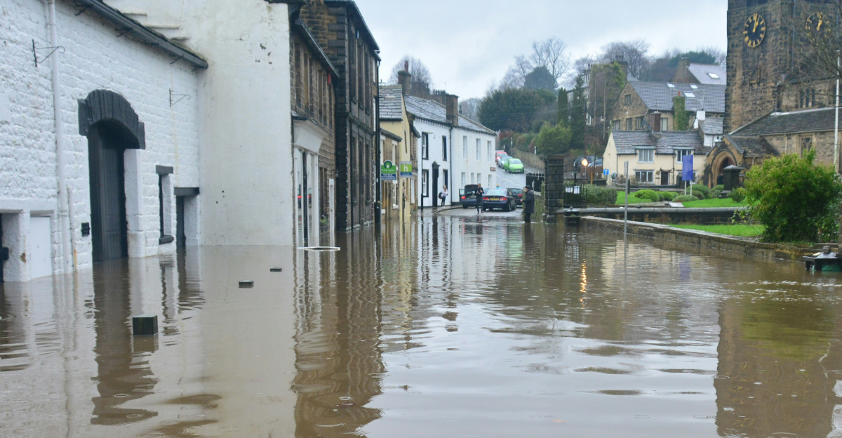
Nowhere did the scale of the flood stand out more than on the Skagit River. Near Mount Vernon, the river crested around 37 feet on December 11, surpassing the previous record set in 1990 and breaking more than a century of gauge data. Officials, who had been tracking forecasts days in advance, issued aggressive evacuation orders as the river approached and then exceeded earlier marks.
According to the Associated Press, “The river crested overnight at 37 feet (11 meters) in the valley’s biggest city, Mount Vernon, surpassing the previous record by a few inches.” Downstream levees were pushed to and in some places beyond their design limits as crews worked around the clock stacking tens of thousands of sandbags to prevent overtopping and breaches.
Elsewhere, the Snohomish River also climbed to an all-time high, while rivers across western Washington approached or surpassed major flood thresholds. The combined effect put extraordinary pressure on flood-control systems from small agricultural dikes to larger urban floodwalls.
Infrastructure and Farms Under Strain

The storms also tore at the region’s transportation and economic backbone. Mudslides buried sections of Interstate 90 near North Bend, shut roughly 50 miles of U.S. 2 over Stevens Pass, and severed stretches of U.S. 12, leaving some communities with few or no passable road links. Ramps on Interstate 5 closed near Napavine as water encroached, and Amtrak suspended trains between Seattle and Vancouver, British Columbia.
Highways and rail lines were not the only systems disrupted. Power and water infrastructure took heavy damage in places such as Stehekin, where slides cut off electricity and choked water intakes, and in parts of Lewis County, which faced boil-water advisories after floodwater contaminated drinking supplies. In Leavenworth, flooding swamped streets and interrupted basic services.
In the Skagit Valley and other agricultural areas, farm fields and barns disappeared beneath brown floodwater. Producers scrambled to move equipment and livestock to high ground, but many faced the loss of stored crops, feed, and future harvests running into the millions of dollars. Across the border in British Columbia, the Fraser Valley around Abbotsford evacuated more than 370 properties while major routes, including Highways 1, 7, and 99, were shut, underscoring how the storm hit a cross-border agricultural and transportation corridor.
Officials noted that events in 2021 and 2024 had already delivered multi-billion-dollar damage tallies for the Pacific Northwest. With this latest disaster, emergency agencies expect a prolonged recovery measured in months and total costs potentially rivaling past billion-dollar floods.
Emergency Powers and an Uncertain Future
Governor Ferguson’s December 10 emergency proclamation unlocked state funding and streamlined the mobilization of resources. He emphasized that the declaration would help Washington seek federal assistance to cover what is expected to be substantial response and recovery costs, and give agencies flexibility to act quickly in a fast-changing situation. President Trump approved a federal disaster declaration within 24 hours, activating Federal Emergency Management Agency Region 10 resources such as mobile kitchens, temporary bridges, and initial financial aid.
By December 14, attention had begun to shift from immediate rescues toward cleanup and rebuilding. National Guard units helped clear key routes like I-90, reopening some lanes even as crews continued to address mudslides and debris piles elsewhere. FEMA brought in temporary housing units for displaced families, while local governments and volunteers distributed food, blankets, and basic supplies.
Yet forecasters warn that additional atmospheric rivers are likely later in December, raising the risk that saturated ground and weakened levees could face another test before current floodwaters fully recede. Scientists say these moisture-laden systems already supply 30 to 50 percent of the region’s annual precipitation, and a warming climate is expected to increase their intensity and the amount of rain falling on snow, amplifying flood hazards.
State and local leaders now confront difficult choices about investing in more resilient infrastructure, targeted buyouts of chronically flooded properties, and new strategies for managing snowpack and river systems. For residents, farmers, and business owners from Skagit County to Lewis County and beyond, the coming months will determine whether this disaster becomes a catalyst for long-term adaptation or another chapter in a recurring cycle of high-cost floods.
Sources:
WA Governor’s Office Emergency Proclamation
USGS Skagit River at Mount Vernon Gauge
NWS Seattle Flood Warnings & Rainfall Reports
WA National Guard Press Releases
FEMA Region 10 Situation Reports